Chance of snow in UK this week after Storm Claudia clears
BBC | 15.11.2025 16:02
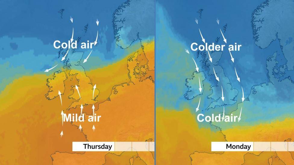
There's a battle taking place at the moment across the UK between mild air and cold air.
On the front line is the band of rain which brought flooding and travel disruption on Friday.
Once this rain clears away this weekend the cold air will sweep the field and bring a regime change with snow for some of us next week.
When is it going to get cold?
For many places it has been very mild since the start of the month. On Thursday the temperature reached 18.7 Celsius (65.6 F) in Surrey. But already the air was much colder in Scotland. Hence the battle.
On Saturday the rain brought by Storm Claudia will die out and on Sunday the colder air starts to arrive from the north. By Monday that cold air will have spread to the whole of the country.
Maximum daytime temperatures on Monday are expected drop by as much as 8 degrees Celsius in England and Wales compared with Thursday. There will also be a more widespread risk of frost.
The cold weather is likely to continue throughout next week before temperatures start to recover next weekend and mild Atlantic air returns.
The UK Health Security Agency, in partnership with the Met Office, has issued yellow cold health alerts for central and northern parts of England between 8am on Monday 17 November to 8am Friday 21 November. It is important to note that warnings are only issued for England.
The significant drop in temperature is due to a change in wind direction.
Since the start of this month there has generally been a southerly wind bringing a very mild, but cloudy, tropical maritime airmass all the way from the Canary Islands.
This pattern will change, and from being on the warmer side of the jet stream the UK will be on the colder side of it.
By Monday the colder air in the north will have been swept southwards on a northerly wind bringing down an arctic maritime airmass - and that means the chance of snow.
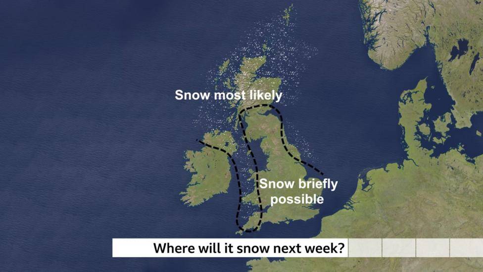
Where is it likely to snow?
It is still a few days away and the details for next week are likely to change.
But at the moment it looks as if there could be wintry showers - a mixture of rain, sleet and snow - mainly over northern Scotland, Northern Ireland, the North Yorkshire Moors, west Wales and the moors of south-west England.
Essentially, areas exposed to the cold northerly wind.
An Atlantic weather system coming into the cold air on Tuesday could bring some snow inland over Scotland and northern England. This could briefly spread to the Midlands and south-east England on Wednesday morning.
It's too early to say though if and where the snow will settle.
It is unlikely to be as bad as the snowy and icy spell this time last year which closed hundreds of schools and gave 12cm of snow in Nottingham.
Over recent decades the Met Office have observed a decrease in the frequency, duration, and intensity of cold spells, clearly linked to climate change. According to the latest State of the Climate Report, air and ground frosts have reduced by around a quarter since the 1980s.